
Smart Outreach
Automate customer communication through AI-powered voice calls, emails, and WhatsApp messages.

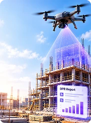
StrategicERP Drone to DPR helps construction and infrastructure teams transform drone-captured imagery into actionable project insights. AI-assisted image analysis supports site progress monitoring, visual documentation, and DPR preparation, helping teams understand site conditions and track project activities more efficiently. The feature is designed to support project monitoring and reporting, while keeping progress validation, measurements, and final reporting under authorized team review.
Precision AI tools engineered for enterprise performance.
Analyze drone-captured images to support site monitoring and progress assessment.
Compare site imagery across different dates to review visible changes and construction progress.
Organize available site observations and project data into structured DPR drafts
Support the identification and review of visible construction activities from available imagery.
Maintain visual records to support project reviews and progress reporting.
Upload drone images, analyze site progress, and generate structured DPR drafts with AI.
Collect aerial images of the construction site and upload supported files.
AI-assisted analysis reviews available imagery to identify visible changes and organize progress observations.
Compile relevant observations into a structured DPR draft for validation and approval by the project team.
Reduce manual effort involved in reviewing site imagery and preparing DPRs.
Gain a clearer visual understanding of construction progress.
Maintain organized visual records for project tracking and reviews.
Help project teams identify progress variations and review potential issues sooner.
Drone to DPR uses drone imagery and AI-assisted analysis to support construction progress monitoring and Daily Progress Report preparation.
It can help organize available imagery and project information into structured DPR drafts. Project teams should validate observations and reporting details before finalization.
Comparing drone imagery captured on different dates can help teams review visible site changes and assess progress, depending on image quality and available analysis capabilities.
It helps reduce manual image-review effort, improves visual progress documentation, and supports faster reporting and project reviews.

StrategicERP from ITAakash Strategic Software (P) Ltd is a software platform for start-to-end process automation and information management systems customized for the Real Estate, Construction & Infrastructure industries. The product owes to its cutting-edge core technology development team, from IIT.
ITAakash Strategic Soft. (P) LTD, 5th floor, D S Business Galleria, Near Huma Adlabs, Beside Toyo House, L.B.S. Road, Kanjur Marg (W), Mumbai, 400078 INDIA.